30-day Overland: Day 26-27
Turkmenistan with 80% of its territory covered in the Karakum (Black Sand) Desert has the world’s fourth largest natural gas reserve. The world famous pure blood Akhal-Teke horse (known as ‘blood sweat horse’ in Chinese) comes from this region. It has three World Heritage Sites including Merv – an oasis-city on the historical Silk Road which was probably the world’s largest city in the 12thcentury. Turkmenistan remains the least known country in Central Asia. I am bewildered by what I have seen during my 5-day stay in the country.
Background
The land of the present day Turkmenistan has a long history. The first modern Turkmen who are nomadic might have arrived from the Altai region in the present day Turkmenistan in the 11th century. Armies from one empire after another had decamped there. The region’s written history begins with its conquest by the Achaemenid Empire (550-330 BC). Then Alexander the Great came in the 4th century BC on his way to Central Asia. Merv already had a great civilization and was a major city along the Silk Road.
The Persian’s Parthian Kingdom (247 BC – 224 AD) established its first capital in Nisa (close to Ashgabat). The next ruler was the Persian Sassanid (224 – 651 AD) till the arrival of the Arabs in the 7th century. The Turkmenistan region came to be known as the capital of Greater Khorasan. The Seljuk Empire ruled briefly before Genghis Khan razed Merv and Konye-Urgench to the ground in the 13th century. For the next seven centuries, the Turkmen people lived under various empires and fought constant inter-tribal wars. By the 19th century, the British Empire and the Russian Empire jogged for control and clashed over the region.
When Turkmen captured thousands of Russian Tsar’s troops and sold them as slaves in Khiva and Bukhara, the Russians retaliated leading to a massacre of Turkmen at Geok-Depe in 1881. The land was later absorbed into the Russian Empire and subsequently became the Turkmen oblast (province) of the Turkestan Autonomous SSR. It was turned into the Turkmen SSR in 1924.
During the Soviet era, an 1100km-long Karakum Canal was built in 1950s to irrigate the land for cash crops. The use of source water bound for the Aral Sea has caused environmental issues not only for the Aral Sea located in Uzbekistan and Kazakhstan but also northern Turkmenistan.
The country has been operating a single party –system. Saparmurat Niyazov was the First Secretary of the Turkmen Communist Party from 1985 to 1991 and its first president when it declared independence in October 1991. During his reign till his sudden death in December 2006, he promoted a cult of personality and posed as the ‘leader of Turkmens’. His slogan was inter alia ‘People, Nation, Me’and he claimed this reign was the ‘Turkmen Golden Era’.People are given free water, gas, electricity and education and subsidies of all sorts. Gurbanguly Berdymukhamedov was elected President in February 2007 and has largely followed the policies set by the first President and repackaged them as the ‘New Era’.
Turkmenistan has a population of five million with ethnic Turkmen in the majority (90%). The country boosts three World Heritage Sites namely the ancient Merv, Konye Urgench with unexcavated ruins of the 12th century capital of Khwarezm and the Parthian Fortress of Nisa which was one of the first capitals of the Parthians.
Day 26 (August 20): Khiva, Uzbekistan – Konye Urgench, Turkmenistan (180km)
 We were met by our local guide, Murat once our truck reached the Turkmenistan border checkpoint. He liaised with the officers and finally got our group visa issued two hours later. I sat on the floor in the waiting floor reading a book and watching the locals who had to wait like us for a long time. The officers closed the counter for an hour for lunch. We had to show our passport and visa at least four times before we could get on our truck and leave.
We stopped at Dashogus, a thriving town five kilometres from the border for lunch and shopping. I had some nice fried fish at the market (7 manat (M); UD$1 = 2.85M). Food especially fruit, is more expensive than those in the other three Central Asia countries. Our cook group spent some 90M on milk, butter, yoghurt and fresh fruit.
We continued along the highway in the Karakum Desert for two hours before reaching Konye (old) Urgench. The city is situated on the shores of the Amu-Darya River and was once the capital of the Khorezm region which was part of the Achaemenid Empire. The deserted old town with several huge mausoleums, some mosques including an unrestored 9th-10th century mosque, a 60-m high minaret and countless graves spreading over several kilometres in the desert, looks ghastly but strangely beautiful at sunset. There is a 1.5km-long path to all major sites.
Murat walked fast while I was slow. He started to talk about the history and unique features of the site before I could even reach the group. Hence I have missed most of what he had said about the ruins.
After spending about an hour at the ruin, we drove for a short distance before finding a site for bush camping. The last sun rays were almost gone when we set up our tents. After a late dinner, I went to bed about 10pm.
Day 27 (August 21): Konye Urgench – Darvaza Gas Crater (290km)
We set off again at 8am. The first 70 kilometres were most dreadful and those sitting at the back were thrown up several times when the truck hit bumps in the road. Then a bridge was closed and we had to drive another 17km to go back to the main highway.
 |
 |
 |
 |
 |
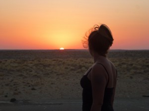 We spent much longer than expected on the road and did not reach our campsite behind a sand dune till 4:30pm. Murat organized four 4WD vehicles to take us to the Darvaza Gas Crater which is 7 kilometres away. Finn’s cook team prepared an early dinner and we set off to the crater at 8pm.
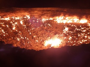
It is an amazing sight when I got off the car. The crater which is about the size of a football pitch is turned into a blazing inferno fed by natural gas. It looks like hell (as often depicted in folklore tales). I got as close as possible to the rim and saw several large fire heads at the bottom of the crater. It was too hot and dangerous to get too close as there are cracks on parts of the rim. Apparently it was ignited during gas exploration in the 1950s.
We stayed for half an hour and returned to the campsite around 9pm. I went to bed early as I had to get up at 5:30am to prepare breakfast. I stared into the starry night with a half-moon in the desert for the last time as I would miss this wonderful sight once I returned to the city.
 |

